Mapping the local environment with Jim Pomplun
by Vicki Heisser |
For PWSC instructor Jim Pomplun, a main focus in his Introductory Geographic Information Systems (GIS) class this semester has been on teaching students about geographically mapping the local environment.
He shares, “We've covered the basic elements of maps and how that relates to modern software and the software techniques and skills you're going to need to use to work in that environment of map-making. We've had an outdoor emphasis here because that's a natural fit to our students in the curriculum.”
Much of what students do in this class is hands-on, and has real world application. Jim explains some of the projects students have worked on this year.
“We had one [student] do a hiking and camping project where he went out and hiked a trail with the GPS, took some photos, geo-referenced the photos, put a presentation together, and then described the methodology of the different skills and techniques he used to build that project. Other students are working on rock and ice climbing areas; ski and snow machine trails as well.”
These projects allow students to engage in the work themselves and develop their mapping skills.
“They're learning these basic skills that will allow them to create good graphics and maps that may be applicable to some of the careers they end up pursuing, or may help them move on to a career in GIS. This is that introductory level that is opening their eyes to that broad use of maps and the internet for online mapping.”
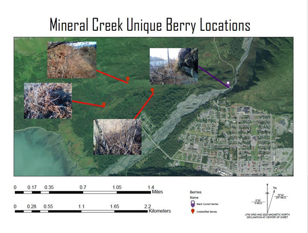
One student in Pomplun’s class, Zac Wenzinger, worked on a project related to one of Valdez’s most popular spots, Mineral Creek.
Wenzinger explained, “My class project…was to map interesting points of interest for myself in the Mineral Creek area. I began the project by bushwhacking 3 days in the Mineral Creek. As I was hiking I marked areas of interest for me with a Garmin E-trex GPS…The four maps that I made include a Mineral Creek overview map, Clean up map, Vantage point map, and Unique berries map.”
For Wenzinger, this class, and this project in particular, allowed him to develop skills in a real world setting, skills he hopes to use in the future.
“Doing this project helped me better understand simple tasks done in ArcGIS such as labeling, adding vectors, adjusting symbology, and making layouts. Overall I was happy with the project and had fun doing the project. This class was great in learning the basics of ArcGIS. Knowing how to use ArcGIS potentially gives me a leg up for being hired on to any company or government agency needing maps to be created.”